当前位置:网站首页>Estimation of dense forest volume based on LIDAR point cloud with few ground points
Estimation of dense forest volume based on LIDAR point cloud with few ground points
2022-06-25 07:39:00 【Oxygen technique】
Based on the rarity of ground points LiDAR Estimation of dense forest volume of point cloud
One 、 Carbon neutralization
2020 year , Our country has made “ Strive to 2030 Reach the peak of carbon by 2000 、2060 It was carbon neutral a year ago ” Major national strategic decisions , And will consolidate the carbon sequestration of existing forests 、 Continue to increase forest area and volume 、 Enhancing the incremental capacity of ecosystem carbon sink is one of the important development paths to achieve carbon neutrality , Pictured 1 Shown .

chart 1 Carbon neutral development path
Talking about carbon , In fact, in the atmosphere 、 land 、 The oceans store a lot of carbon , Forests are the largest carbon pool in terrestrial ecosystems , Pictured 2 Shown . Forest biomass 、 Litter 、 Soil is a carbon pool , Including wood products formed after forest cutting also store carbon . The specific amount of carbon in the carbon pool is called “ Carbon storage ”, It's usually used “ Ton carbon ” As a unit of measure . However , The amount of carbon in the carbon pool is not static , Both in and out . The process of carbon entering the carbon pool , It's called carbon sequestration ; Carbon goes out of the carbon pool , It is called carbon emission . For the carbon pool , More carbon comes in than goes out , A carbon sink is formed , Otherwise, it is a carbon source . Take the forest for example , The process by which plants store carbon dioxide through photosynthesis is carbon sequestration , And plant death decomposes 、 fire 、 Man made deforestation will cause carbon emissions . When a forest's fixed carbon exceeds its emissions , Form a carbon sink ; conversely , It is possible to form a carbon source . It is worth noting that , Is forest a carbon sink or a carbon source , Over time 、 Space changes .
chart 2 The forest
Two 、 Investigation of forestry resources based on laser radar
Accurate calculation of forest volume is an important part of carbon neutralization . Traditionally , Forest volume survey is an important survey content , It is one of the most important indicators to reflect the number of forests . Quantification of forest stock 、 Accurate estimation has always been the focus and difficulty of forestry investigators . meanwhile , The quantitative estimation of forest stock is also the main way for the government to master the state of national forest resources .
Laser radar (Lidar) It is an active remote sensing technology , Accurately obtain three-dimensional coordinate information through laser beam , To quantitatively estimate tree height and forest structure parameters , Combined with the ground sample plot investigation and mathematical model inversion technology, the forest volume in a large area can be quickly obtained 、 Biomass 、 Carbon reserves and other information , On a large scale 、 High aging 、 High precision forest height and stand vertical structure information acquisition is more accurate than other data acquisition methods 、 Three dimensional advantages .
We developed PCA The software has been integrated into the foundation 、 hold 、 knapsack 、 Airborne and other multi platform LIDAR point cloud forestry information extraction module , Not only can single wood be divided 、 Extract the height of single wood 、 Location 、 Crown diameter 、 Volume and other parameters , And the height of the sample plot can be 、 Extraction of density and structure parameters .PCA Software forestry information extraction has been applied to 2019 Northeast forest resources investigation project of the Ministry of natural resources 、 The forest resources investigation project in Toyama Prefecture, Japan 、 Anhui Huangshan single tree segmentation and information extraction demonstration project .
PCA The technical process of single tree segmentation and information extraction in the software is shown in the figure 3 Shown , The whole system uses one key 、 Non parameterized processing mode .

chart 3 PCA The overall technical flow chart of single tree segmentation and information extraction in the software
3、 ... and 、 Unmanned aerial vehicles with sparse ground points under the forest LiDAR Forestry resources investigation of point cloud
For wooded forests , Unmanned aerial vehicle (uav) LiDAR Obtained point cloud data , The number of points in tree canopy is generally large 、 It can reflect relatively complete canopy information , However, lidar may not be able to penetrate the vegetation canopy 、 The ground points under the forest may be extremely sparse 、 Even missing . However, the lack and incompleteness of understory terrain information will lead to the failure of single tree segmentation 、 Incorrect calculation of single wood height .
In order to better solve such problems , combination PCA3.5 The ground point inversion function launched by the function , We designed a new UAV with sparse ground points under the forest LiDAR The technical route of forestry resources investigation of point cloud , Pictured 4 Shown . And graph 3 Compared with the technical process of , New technologies add “ Inversion of ground points 、 Merge the inverted ground points with the original point cloud ” These two steps , The other steps remain the same .
chart 4 PCA The overall technical flow chart of single tree segmentation and information extraction combined with the function of retrieving ground points in the software
Four 、 Case study
The test area is located in a dense forest area in Hangzhou, Zhejiang Province , Using a certain type of UAV LiDAR The device obtains the corresponding point cloud , Pictured 5(a) Shown , The terrain elevation difference of the forest land is about 240 Rice or so , Things are long 1203 rice , The north-south width 957m. However, the ground points under the forest of the forest point cloud are extremely sparse , Pictured 5(b) Shown . The origin cloud data is las1.2 Format , The size is 7.42G.
Many anomalies have been found in the single tree segmentation and information extraction of the original point cloud , For example, the height of trees is too high , The number of single trees obtained is small , It is quite different from the overview data provided by the forestry department .
We use the 3 Some new technical routes for single tree segmentation and information extraction , among , The inversion ground points are shown in the figure 6 Shown 、 The profile of the point cloud after the combination of the origin cloud and the inversion ground point is shown in the figure 7 Shown . The retrieved ground points are saved as las1.2 Format , The size is 23.753M, The inversion ground points are shown in the figure 6 Shown .. also , chart 7 Section and drawing in 5(b) The section positions in are basically coincident . further , The single tree distribution result obtained is shown in the figure 8 Shown .
(a) Unmanned aerial vehicles with sparse ground points under the forest LiDAR Point cloud 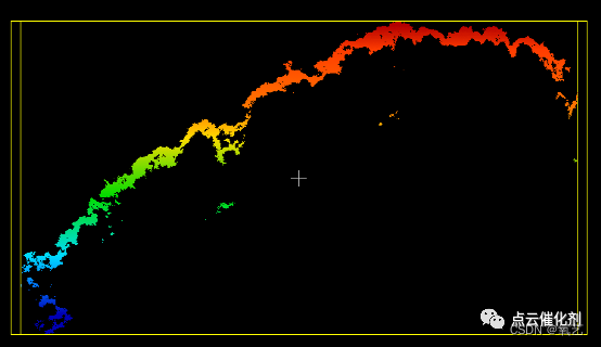
(b) Some section point cloud data ( Ground points are extremely rare )
chart 5 Point cloud data of the test area
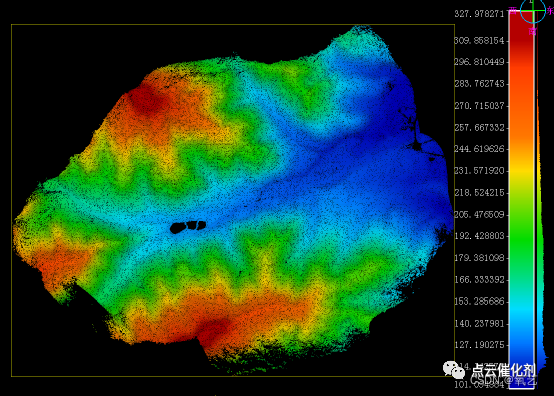
chart 6 PCA The ground points derived from inversion

chart 7 The section point cloud after the origin cloud is merged with the inversion ground point ( This section and drawing 5(b) The section position of is basically the same )

(a) Merge the classification effect of the point cloud

(b) Merge the single tree segmentation effect of the point cloud

(c) Single wood 3D reconstruction superimposed to DEM Simulation effect of

(d) Single wood 3D reconstruction superimposed to DEM Simulation effect of ( Partial enlarged view )
chart 8 Single tree segmentation and information extraction results of the merged point cloud
The generated special report shows , A total of... Are extracted from the merged point cloud 12942 Trees , Average tree height 13.38m, The average diameter at breast height is 17.50cm, The forest volume of this woodland is 2976.07 Cubic meters .
5、 ... and 、 Summary
The investigation of forestry resources based on laser radar technology has the advantage of high speed 、 High precision 、 Advantages of labor saving . When the ground spots under the forest are extremely rare , We can use the inversion function of point cloud intelligent mapping to obtain relatively accurate terrain under the forest , To assist the original LIDAR point cloud to complete the task of forestry resources investigation . You know , The function of retrieving ground points from point cloud intelligent mapping has a wide application value in forestry resources investigation .
边栏推荐
- STL教程4-输入输出流和对象序列化
- Hanxin's trick: consistent hashing
- Modular programming of digital light intensity sensor module gy-30 (main chip bh1750fvi) controlled by single chip microcomputer (under continuous updating)
- Loopholes in the missed scanning system of Lvmeng and its repair scheme
- VectorDraw Developer Framework 10.10
- Tempest HDMI leak receive 1
- IAR compiler flashback
- Authentique Photoshop 2022 expérience d'achat partage
- Domestic MCU perfectly replaces STM chip model of Italy France
- This year, I graduated
猜你喜欢

Design a MySQL table for message queue to store message data

14 bs对象.节点名称.name attrs string 获取节点名称 属性 内容

为什么要“除夕”,原来是内存爆了!

Sichuan earth microelectronics ca-is1200 isolated operational amplifier for current detection

Ltpowercad II and ltpowerplanner III

Don't you know the evolution process and principle of such a comprehensive redis cluster model?

VectorDraw Developer Framework 10.10
![[batch dos-cmd command - summary and summary] - file and directory operation commands (MD, RD, xcopy, dir, CD, set, move, copy, del, type, sort)](/img/fd/1d83ab3b318413ddf70f4e68b28cc3.png)
[batch dos-cmd command - summary and summary] - file and directory operation commands (MD, RD, xcopy, dir, CD, set, move, copy, del, type, sort)

Sichuan Tuwei ca-is3105w fully integrated DC-DC converter
![[C language] one dimensional array](/img/6a/e8b1d418fb8a7680e024e9bd8b3ec1.jpg)
[C language] one dimensional array
随机推荐
Introduction to Sichuan Tuwei ca-is3082w isolated rs-485/rs-422 transceiver
Display purchase Summary - Dell 2705qm BenQ pd2700u
LabVIEW jump to web page
Notes: [open class] neural network and deep learning -- tensorflow2.0 actual combat [Chinese course]
[batch dos-cmd command - summary and summary] - external command -cmd download command and packet capture command (WGet)
Debian introduction
Harmony food menu interface
Chuantu microelectronics high speed and high performance rs-485/422 transceiver series
The e-book "action guide for large organizations to further promote zero code application platform" was officially released!
Evolution of Alibaba e-commerce architecture
【批處理DOS-CMD命令-匯總和小結】-外部命令-cmd下載命令、抓包命令(wget)
Common functions of OrCAD schematic
Distributed quorum NWR of the alchemy furnace of the Supreme Master
韩信大招:一致性哈希
国外LEAD域名邮箱获取途径
Enter an integer with any number of bits, and output the sum of each bit of the number. For example: 1234 – > 10
keepalived監控進程,自動重啟服務進程
Chuantu microelectronics ca-if1051 can-fd transceiver
【批处理DOS-CMD命令-汇总和小结】-文件与目录操作命令(md、rd、xcopy、dir、cd、set、move、copy、del、type、sort)
Classic paper in the field of character recognition: aster