当前位置:网站首页>ROS rviz_ Satellite function package visualizes GNSS track and uses satellite map
ROS rviz_ Satellite function package visualizes GNSS track and uses satellite map
2022-06-28 06:09:00 【On the way_ continue】
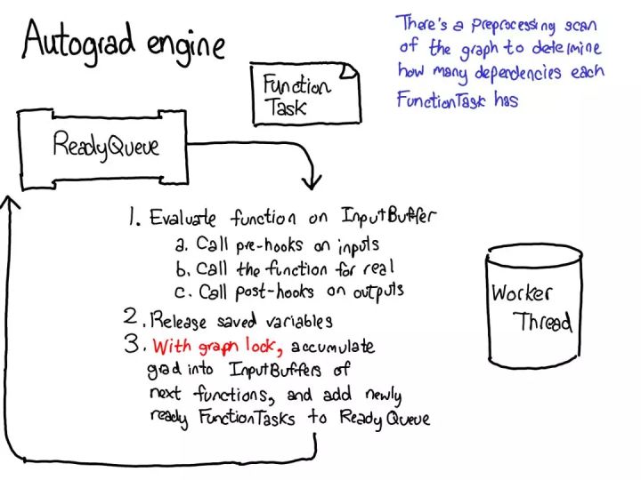
Installation steps
mkdir -p catkin_ws/src
cd catkin_ws/src
git clone https://github.com/nobleo/rviz_satellite   # clone Function pack

cd ..
catkin_make  #  compile , If an error is reported during compilation , It is recommended to use rosdep Tool installation dependency
Usage method :
Play contains gnss Information function package , see "/fix" The longitude and latitude height in the initial positioning state of the topic , If this is a difference RTK, It is suggested that the longitude and latitude height when the fixed solution is adopted .
 The longitude and latitude height shown in the above figure and position_covariance Need to fill in rviz_satellite Of demo.gps In the configuration file .
 demo.gps The message type stored in the file is sensor_msg/NavSatFix A frame of data .
You can start after configuring to basic rviz_satellite Feature Pack , function launch file
roslaunch rviz_satellite demo.launchSome introduction to parameters :
Focus on Rviz Interface Zoom and Blocks These two parameters .
Readme.md These two parameters are introduced in the document :
- `Zoom` is the zoom level of the map. Recommended values are 16-19, as anything smaller is _very_ low resolution. 22 is the current max.
- `Blocks` number of adjacent blocks to load. rviz_satellite will load the central block, and this many blocks around the center. 8 is the current max.
Personal understanding :
-Zoom: The focal length , Similar to resolution . The greater the numerical , The clearer the satellite map , Again Rviz The smaller the range of the satellite map displayed in .
-Blocks: The greater the numerical , The larger the range of the loaded satellite map .
commonly Zoom and Blocks These two parameters are set at the same time , Select the optimal value .
Attach a picture of yourself running out :
The green line in the picture is drawn GNSS The trajectory , I didn't use the difference here , So the trajectory doesn't look very smooth . Visualization involves some coordinate transformation , No introduction here . In theory, it's WGS84 turn ENU.
边栏推荐
- AutoCAD C# 多段線小銳角檢測
- Yygh-8-appointment registration
- Data middle office: an article that takes you to understand data middle office in simple terms
- Parsing ng template with let total in NZ Pagination
- 6. graduation design temperature and humidity monitoring system (esp8266 + DHT11 +oled real-time upload temperature and humidity data to the public network server and display the real-time temperature
- Oracle condition, circular statement
- 基本类型和包装类的区别
- Caused by: com. fasterxml. jackson. databind. exc.InvalidDefinitionException: Cannot construct instance
- Mosaic data enhanced mosaic
- How to add live chat in your Shopify store?
猜你喜欢

Difficulty calculation of Ethereum classic
pytorch详解

How popular are FB and WhatsApp mass messages in 2022?

Deep learning 19 loss functions

高质量国产立体声编解码器CJC8988,Pin to Pin替代WM8988

YYGH-7-用户管理

Jenkins continuous integration 1
链表(一)——移除链表元素
深度學習19種損失函數

Valueerror: iterative over raw text documents expected, string object received
随机推荐
SQL and list de duplication
Caused by: com.fasterxml.jackson.databind.exc.InvalidDefinitionException: Cannot construct instance
【无标题】
基于Kotlin+JetPack实现的MVVM框架的示例
Configure multiple database connections using the SSM framework
Development trend of mobile advertising: Leveraging stock and fine marketing
Oracle fundamentals summary
Yygh-8-appointment registration
Caused by: com.fasterxml.jackson.databind.exc.InvalidFormatException:异常解决
Prime mover × Cloud primordial is making sound, reducing cost and increasing efficiency lecture hall
5g network overall architecture
YYGH-BUG-03
Deep learning 19 loss functions
Taobao seo training video course [22 lectures]
High quality domestic stereo codec cjc8988, pin to pin replaces wm8988
Maskrcnn, fast RCNN, fast RCNN excellent video
OpenSCAP 简介
Valueerror: iterative over raw text documents expected, string object received
At first glance, I can see several methods used by motionlayout
异常处理(一)——空指针和数组索引越界